USAID’s climate change program is working to reduce greenhouse gas emissions that result from the way land resources are managed. Destructive logging, forest fires, agricultural expansion, and conversion to pastureland contribute significant amounts of greenhouse gases to the atmosphere each year.
The international climate community promotes an effort known as REDD+ (Reducing Emissions from Deforestation and Forest Degradation), which offers financial incentives to developing countries to conserve and enhance the stocks of carbon in their forested lands. Determining the amount of carbon in a forested landscape and monitoring the change in carbon stocks over time requires geographic information. Making maps of the landscape is also essential to addressing many other natural resource management and development challenges.
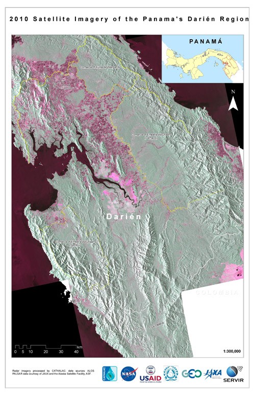
SERVIR, which means “to serve” in Spanish, is a program that uses geographic and satellite information to monitor and manage natural resources more effectively. It provides developing country governments with the capacity to monitor and forecast the weather, forest fires, air quality, and ecological changes, as well as respond to severe events such as red tides, landslides, and flooding.
Essentially, the SERVIR program helps managers make better decisions. In addition to generating forecasts, it can be used for visualizing environmental changes, which enables scientists, educators, project managers, and policy implementers to better respond to a range of issues including disaster management, agricultural development, biodiversity conservation, and climate change.
SERVIR, which is a partnership between USAID and NASA, boasts three regional centers in Panama, Kenya, and Nepal, serving the countries in Mesoamerica, Eastern Africa, and the Hindu-Kush Himalaya regions. Each center houses a team of local specialists with expertise in remote sensing, geographic information systems (GIS) mapping, and database management.
New tools are being developed to address sustainable landscapes and climate adaptation. For example, in Africa, the SERVIR program will use satellite imagery to generate time-series land cover maps for eight East African countries. This important first step will help to establish a baseline for calculating how much carbon is stored in the land, and how emissions of carbon dioxide increase or decrease as land use management changes over time.
SERVIR-Himalaya will monitor snow and glacial melt to inform managers of downstream water supply in Asian countries. Basanta Shrestha, based in Nepal with SERVIR-Himalaya at the International Center for Integrated Mountain Development, summarized his enthusiasm for the USAID-NASA SERVIR partnership: “SERVIR-Himalaya will be a key milestone in providing innovative solutions that integrate earth observation with geospatial tools for informed action and decision support in the areas of environmental and natural resources management in the region.”



Comment
Make a general inquiry or suggest an improvement.