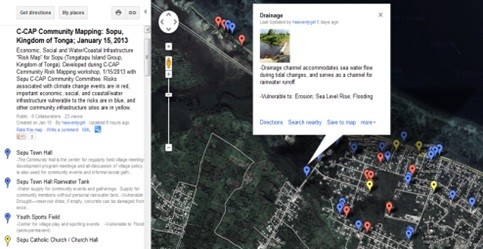
July 2014—Pari Taota village, located just outside Port Moresby, the capital of Papua New Guinea, is one of many Pacific Island communities besieged by the effects of climate change and other natural events. Now its challenges are represented on Google Maps.
USAID, through its Coastal Community Adaptation Project (C-CAP), is helping 20 communities in the Pacific Islands region, including Pari, to identify and assess climate change risks and vulnerabilities of critical infrastructure with social, economic and cultural importance. By January 2014, images of community infrastructure, such as community rainwater collection tanks, and climate change risks, like low-lying areas which frequently flood during periods of heavy rain or king tide events, were incorporated into the Google Maps of 20 C-CAP partner communities across Fiji, Papua New Guinea, Samoa and Tonga. These maps will be used by communities when they prioritize infrastructure for adaptation support from C-CAP.
Tom Guba, Mase Oala and Ovia Oala, who are members of the Pari C-CAP Community Committee, explain that Pari is frequently impacted by storm surge and other extreme weather events such as strong winds coming off the coast. This is significant in Pari and other coastal communities in Papua New Guinea where large percentages of village homes are built above coastal waters and storm surges crash against the homes' stilted foundations and walkways.
Plotting important infrastructure on Google Maps is a long-awaited start to adaptation in the community. “Our community had given up waiting for help until C-CAP began risk assessments. Mapping our infrastructure as a village was an important educational exercise for all of us,” said Pari Councilor Nou Mataio Nou-Taboro. “Now the world can see our small community and how important it is to help us adapt. We are so thankful to USAID for addressing disaster risk as a priority.”
C-CAP facilitated climate change risk and infrastructure mapping activities across the region from November 2012 to February 2013. The project team developed a standard methodology to determine the type of climate-related impacts taking place and what community infrastructure, whether man-made or natural, was affected. The risks and infrastructure information were then gathered and registered in the Google Maps platform. This information provides the basis for longer-term disaster risk preparedness and land use planning.
C-CAP runs from October 2012 to September 2017. USAID’s climate change program will support Pacific Island nations to reduce long-term impacts associated with climate change and achieve sustainable climate-resilient development.
LINKS



Comment
Make a general inquiry or suggest an improvement.