 A scene from one of the many waterways located throughout downtown Dhaka, Bangladesh
Jessa Gaul
 A scene from one of the many waterways located throughout downtown Dhaka, Bangladesh
Jessa Gaul
In May, the first rains of the monsoon season are just starting to fall. In some countries, the rains signal relief. In Bangladesh, they mean preparing for potential disaster.
“Due to the position and [flat] topography, Bangladesh is a very, very flood vulnerable country, and it is one of the top vulnerable countries due to climate change,” says Amirul Hossain, executive engineer for the Bangladesh Flood Forecasting and Warning Center (FFWC).
Climate change effects such as increased rainfall, glacial melting and rising sea levels make a bad situation even worse. In a normal year, close to one-third of the country may be flooded; in some years, 75 percent of the country may be under floodwaters. One of the deadliest storm surge flooding events occurred in November 1970, when an estimated 300,000 people were killed by Cyclone Bhola.
“You can imagine the suffering,” added M. Monowar Hossain, executive director of the Institute of Water Modelling. “Yet we can’t change our topography.”
Bangladesh is home to almost 160 million people. This densely populated country—barely larger than the state of New York—sits in the “sink” of the second largest river basin in the world, the Ganges-Brahmaputra-Meghna river basin.
These three rivers originate thousands of miles away in India, Nepal, China and Bhutan, and pass through Bangladesh to then drain into the Bay of Bengal. With heavy rains and snow melt from the Himalayas and rising sea levels, the rivers can swell to 20 times their normal widths.
While Bangladesh can’t change its landscape, the country is taking steps to reduce the human, social and economic impacts of floods. And SERVIR, a joint initiative of USAID and NASA, is helping the Government of Bangladesh by increasing flood warning lead time from five days to as much as eight days. The solution involves a satellite circling the Earth.
“For the first time, we are looking up at the sky to get the water information to feed into the model to generate flood forecasts for our country,” says Amirul Hossain.
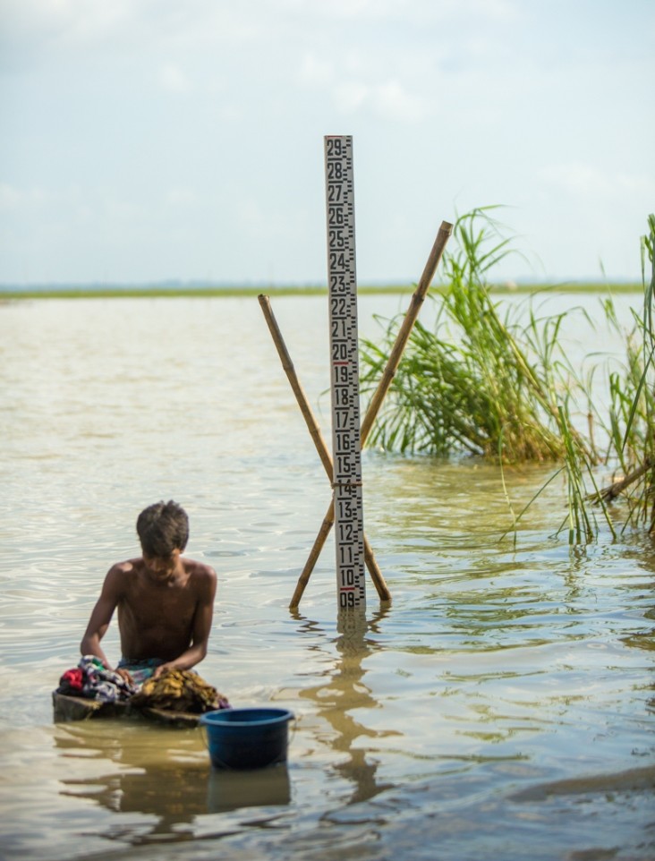
For years, the FFWC has used ground-based stations to monitor river flow (volume). However, more than 90 percent of the drainage flows are generated beyond Bangladesh’s borders. Because data outside its borders is not easily accessible, it has been extremely difficult to accurately predict the volume of water headed for Bangladesh. The best FFWC has been able to do, based on available ground station data, is issue flood forecasts five days in advance.
Enter NASA’s Jason-2 satellite in 2014, unconstrained by the “ground rules” of political boundaries.
“Jason-2 looks 1,000 miles beyond our territorial boundary where we get no ground information,” explains Amirul Hossain.
A radar altimeter on Jason-2 measures the precise distance between the satellite and the river surface at points where the satellite crosses overhead. This data, available almost immediately, reveals the river’s height at the point of crossing, so flood risks downstream can be assessed realistically for large rivers.
With its eye on headwaters, this satellite tracks levels of the Ganges and Brahmaputra Rivers in the neighboring countries upstream of Bangladesh and enables FFWC to produce daily eight-day flood forecasts of water levels for several water stations. Based on the Jason-2 data, FFWC can recognize impending floods and alert the public three to five days sooner than they could previously.
“This provides more time for people to [build platforms that] raise their houses above flood levels or evacuate to a safe place,” says Amirul Hossain. The extra days are especially important in a country where 70 percent of the people live in rural areas and 75 percent of the poor look to agriculture for their livelihood. Increased lead time about rivers swelling ominously upstream allows farmers to relocate their livestock and make proactive decisions on early harvest or delayed sowing or fertilizing.
Time is also of the essence to protect businesses, schools, hospitals and other infrastructure as well as mobilize emergency response.
“The flood information helps almost 100 million people in our country,” says Amirul Hossain.
Information, in fact, is the key to SERVIR’s success.
“SERVIR is providing access to satellite information and helping people use it to answer critical questions, and that is increasing awareness of what satellite information can do,” says Jenny Frankel-Reed, who leads the SERVIR program at USAID.
“In the best cases, such as flood forecasting in Bangladesh, we are seeing something even more powerful happen. We are seeing villagers and policymakers alike taking actions that are saving lives and livelihoods.”
Noemi Danao-Schroeder is the chief of party for the SERVIR Program Demand Activity. Dauna Coulter is a science writer with NASA.






Comment
Make a general inquiry or suggest an improvement.