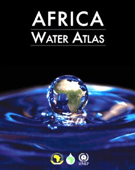
The Africa Water Atlas, compiled by the United Nations Environment Program (UNEP), includes more than 224 maps and 104 satellite images. Hundreds of 'before and after' images, spanning as many as 35 years, carefully detail Africa's major water resource challenges to include not only the drying of Lake Chad and declining water levels of Lake Victoria, but oil spill pollution in Nigeria.
Only 26 of Africa's 53 countries are on track to achieve the Millennium Development Goal (MDG) 2015 target to reduce by half the proportion of the population without sustainable access to drinking water. Only nine countries in Africa are expected to meet this goal for sustainable access to basic sanitation.
With about 100 million people experiencing water-constrained, rain-fed agriculture and climate driven food insecurity, Africa is known as a global "hotspot". But the Atlas, overlays for the first time, "hopespots" on maps to reflect, for example, the positive effect in the Horn of Plenty of harvesting rainwater to mitigate risks to farmers and food security. The Atlas also cites positive water management action taken to protect against, and reverse, degradation. Despite these gains, Atlas research indicates that Africa's available water-per-person allotment is far below the global average and declining.
This 326-page resource, compiled at the request of the African Minister's Council on Water in cooperation with the African Union, European Union, U.S. Department of State, and United States Geological Survey, shows how Africa's water scarcity challenges are compounded by high population growth, socioeconomic and climate change, and policy choices. Other findings indicate that Africa has under-utilized aquifer resources that could meet water needs during drought, and, with 63 shared water basins, has successfully negotiated 94 international water agreements to cooperatively manage shared water, despite the potential for conflict that shared transboundary water resources present.
Authors of the Atlas state: "Africa faces a situation of economic water scarcity, and [Africa's] current institutional, financial, and human capacities for managing water are inadequate." The Atlas uses the latest remote sensing technology to carefully examine and detail each country's MDG water-target progress, citing both challenges and accomplishment. UNEP officials hope that this type of analysis will provide the kind of "hard, evidence-based data that will support political decisions aimed at improving management of Africa's surface basin and aquifer resources."
S. Gudnitz, M. Davis
The Atlas, along with its summary for Decision Makers, is available for purchase in hardback or for free download at: http://na.unep.net/atlas/africaWater/book.php.



Comment
Make a general inquiry or suggest an improvement.