Flood Warning Systems on the Zambezi River
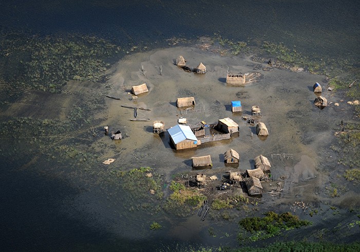
The Zambezi River has always experienced periods of flooding. For countless generations, residents of the Zambezi River Basin relied on the regular deposit of rich sediments from flooding for growing crops and providing ample amounts of food from productive freshwater fisheries. These populations adapted to seasonal flooding by devising traditional warning systems – drumming the message of imminent flooding from one community to another – which allowed households ample time to move to higher ground. When the flood waters receded, the residents returned and planted crops in the enriched soils. Life along the Zambezi River Basin was not easy. But by incorporating an understanding of seasonal flood risks and community-based early warning into their lives, communities along the Zambezi mitigated the river’s risks, while reaping its rewards.
The Zambezi River, the largest in Southern Africa, runs for 2,220 miles through seven riparian states, including Angola, Botswana, Namibia, Malawi, Mozambique, Zambia, and Zimbabwe. The Zambezi River Basin covers over 54 million square miles (140 million square kilometers) and is home to over 32 million people. Over this wide area, many vulnerable communities have been affected as the frequency of intense and damaging floods and droughts along the river has increased in recent years.
The traditional balance achieved by river communities in mitigating risks while gaining rewards began to change with the construction of two hydroelectric dams and reservoirs, the Cahora Bassa in Mozambique and the Kariba between Zambia and Zimbabwe, on the Zambezi River in the 1970s. The dams were built to provide electricity that would enable the
development of other economic activities in the region and decrease the heavy dependence on the agricultural sector. However, the dams altered the natural cycle of flooding on the river, making the pulses of water irregular. Although this decreased flood risks by regulating river flow, agricultural productivity declined as alluvial soils were no longer deposited on the flood plains. Productivity of fisheries declined as well.
As more people moved onto the Zambezi flood plains with reduced seasonal flooding, these residents became more vulnerable to now irregular, more intense flooding. That vulnerability compounded by the effects of changes in land use, environmental degradation, and the pattern of water release from the dams, which may be exacerbated by climate change. Affected communities’ risk factors are especially heightened when higher than normal inflows occur simultaneously with tropical cyclones. The ensuing floods take lives, destroy homes, kill livestock, ruin standing crops, and damage or destroy essential infrastructure. Water- and vector-borne diseases – from dead livestock, sewage, and stagnant water that encourages breeding of malaria-bearing mosquitoes – have increased significantly, undermining the health of communities in the river basin.
Traditional warning systems do not meet the needs of such an expansive population spread over so many countries. “Our country is extremely vulnerable to floods, being the most downstream in the Zambezi basin. But we must rely on information from the upstream countries to better predict flood times and risks,” said Mr. Mussa Mustafa, of Mozambique’s National Institute of Meteorology. Limited infrastructure for timely sharing of meteorological and hydrological information among the Zambezi basin countries has handicapped preparatiofor and mitigation of floods in the region. “The water does not know when it is coming into another country! We should flow like the water (in sharing information),” said Mr. Mustafa. What is needed, in effect, is a modern equivalent of the traditional warning system that spans the countries within the basin, where drums are replaced with more contemporary prediction and early warning and communication systems.
USAID’s Office of Foreign Disaster Assistance (USAID/OFDA), is partnering with the World Meteorological Organization, the National Oceanic and Atmospheric Administration, the U.S. Geological Survey, and the national meteorological and hydrological services and disaster management agencies of the Zambezi River Basin countries to effectively address this specific concern. USAID/OFDA is supporting a program to assess flood forecasting and early warning capacity and develop a basin-wide strategy to flood early warning. The Zambezi River Basin Flood Forecasting and Early Warning System (FFEWS) project will address the technical, institutional, and capacity building issues related to developing flood preparedness and early warning systems.
The project will be implemented through the following activity areas: 1) regional and national consultations to identify information and capacity gaps and the development of strategies to address these gaps; 2) basin-wide meetings of riparian hydrometeorological and disaster management organizations; 3) the development and implementation of a demonstration project involving a flood forecasting system in the area covering the lower Zambezi catchment (including the border area between Malawi and Mozambique); and 4) the compilation of a proposal for a basin-wide flood early warning strategy.
In December 2009, a regional consultation meeting was organized in Maputo, Mozambique to implement the first activity. Based on the discussions at the meeting, the Zambezi River Basin countries have achieved a regional consensus on the development of a flood forecasting and early warning system for the Basin, including real-time sharing of flood warnings and hydrological information. By virtue of the size of the river basin, the effort involves all the affected riparian states – an acknowledgement of their interdependence and the need for regional collaboration.
“The activities we support are primarily at the local or community level. Things like water harvesting, reforestation, better soil and land management, and more efficient farming. But linking them to a regional flood early warning system will make them so much more effective,” said Farid Aiyawar, International Federation of Red Cross and Red Crescent Societies (IFRC) Disaster Management Coordinator. Linking the regional strategy to IFRC activities in the Zambezi River Basin, as well as other FFEWS pilot projects, will address both root causes and the community-level impact of recurrent floods as well as assess the impact of the regional strategy and information sharing on local disaster risk reduction activities. The Zambezi River Basin FFEWS project is one of several ongoing projects funded through USAID’s OFDA, working to reduce vulnerability to hydro-meteorological hazards while promoting integrated, resilient responses to the effects of climate change.
While continuing to provide multiple benefits to communities, the evolving flood patterns along the Zambezi now present greater challenges, which increase risks for already vulnerable residents in these areas. The long-established systems for ensuring household and community livelihoods have been disrupted, leaving the well-being and economic development of the region’s inhabitants gravely threatened. The development of a sustainable, integrated flood early warning and mitigation strategy in the Zambezi basin will enable the inhabitants to increase resiliency to climate variability and adapt to the effects of climate change, reducing the negative impact of potential floods in this vast and vulnerable region.
J. Hutchins



Comment
Make a general inquiry or suggest an improvement.